Extreme Weather to Affect U.S. From Coast to Coast This Week
A conveyor belt of extreme and powerful weather systems is expected to move across the United States this week, bringing blizzards to the center of the country and heavy rain and flash flooding to the Northeast, forecasters warn.
“It’s a pattern where we can see relatively strong storm systems running from the Western U.S. across the country to the East over a period of several days,” Greg Carbin, the branch chief of forecast operations for the National Weather Service, said on Sunday.
That pattern, he said, is “producing a combination of winter weather, but also severe storms and wet weather.”
The Plains face blizzards.
Blizzard warnings have been issued for parts of the Central and Southern High Plains through early Tuesday.
A blizzard is expected to wallop portions of Colorado, Kansas, Nebraska, New Mexico, Oklahoma and Texas. Wind gusts of up to 70 m.p.h. will create “ferocious blizzard conditions with whiteouts,” forecasters said on Monday.
The snow is expected to make travel extremely dangerous, if not impossible, and weather watchers suggested that anyone traveling carry a winter survival kit, as wind chills will fall below zero.
The Midwest could get up to a foot of snow in certain areas, forecasters said.
“A variety of hazards are anticipated with this next storm system,” Mr. Carbin said, adding that power failures were likely because of strong winds and heavy snow. “Travel may be impossible in some parts of the central U.S. as we go into the week.”
The Weather Service said that the storm was expected to move over the middle Mississippi Valley to the upper Great Lakes on Tuesday evening.
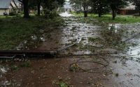
Heavy rains and flooding are likely in the Northeast.
Widespread rainfall of two to four inches is expected on Tuesday throughout the Northeast.
Melting snow from a weekend winter storm that brought a foot or more of snow to some parts of the East Coast could contribute to the runoff and increase the risk of flooding, meteorologists said.
“The associated heavy rain will create numerous areas of flash flooding,” the Weather Service said. “Furthermore, many streams may flood, potentially affecting larger rivers.”
Forecasters identified a large area around Philadelphia where significant river flooding is likely. In total, weather experts are predicting at least 19 rivers in the Mid-Atlantic region will see flooding.
Flooding is also possible from as far south as Richmond, Va., to as far north as the Catskills in New York, according to forecasters.
There’s a risk of tornadoes in the Gulf Coast.
In the Gulf Coast, there is an enhanced risk of severe thunderstorms Monday night into Tuesday morning, with frequent lightning, powerful wind gusts, hail and a few tornadoes, according to the Weather Service.
Significant river and flash flooding are likely for the central Gulf Coast and Eastern states through early Wednesday.
Rain and snow will fall in the Pacific Northwest.
Rain and snow are expected to fall in the Seattle area on Monday and Tuesday, according to the Weather Service.
The Weather Service posted winter storm and blizzard warnings for the Olympic and Cascade Mountains above 2,000 feet. For areas in the blizzard warning, the forecast called for snow accumulation of up to 40 inches and winds gusting as high as 60 miles per hour.
Referring to the storm system in the Pacific Northwest, Mr. Carbin said, “It’s a bit uncertain, but this storm does appear to bring rain and wind to the East Coast, and possibly snow inland” by the weekend.
Derrick Bryson Taylor contributed reporting.

What $50 Million Can Buy: Inside the Sleek New White House Situation Room
Texas Utility Considers Mobile Generators as Beryl Leaves Millions Without Power